
|
|
My partner for this day was my friend Rie. Due to the horrendous crowds I expected at Lake Louise, I decided to leave my home by 7am to arrive at the lake by 9am. Unfortunately, my plan backfired when I realized that I had forgotten my boots in my garage... 20km out of town. What a way to start off a long day ! After returning home and driving back out, I eventually pulled into the upper parking lot at around 9:30am where we were greeted with tons of tourists. The lake was already a zoo as we quickly made our way up to Lake Agnes to get away fromt he crowds which were growing like mold on a old slice of bread.
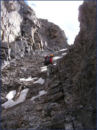
As we got closer to the top, it got a little steeper and required climbing up what seemed like an endless number of mini ledges. The ledges weren't bad but they were covered with loose rock. Can you spot my partner in the image to the left ?
The register at the summit resembled someone's diary since there were so many entries ! We came across a total of 8 people during this day but I never realized how popular it was until I saw the register. The view from the top was great but my mind seemed to be occupied on Whyte to the south. After a leisurely 30 minute break at the summit, it was time to check out the higher half. Here's Niblock to the left and Whyte to the right from the col.
Whyte may have been one of the most interesting scrambles I've done to date. In contrast to the other scrambles which lead you by hand with a well marked trail or cairn, Whyte forces you to stop and think. It also tries to confuse you by scattering a bunch of false trails all over the mountain. At any given intersection, there were 2 or 3 trails going off in various directions. An excellent scramble for those into puzzle solving. Spoiler Alert ! The following is a pretty detailed explanation of the route. :) After following the crest of the ridge for about a minute, we came face to face with a vertical wall which we preferred not to climb. Two trails were present here. One of them descended to the left while the other went around to the right. After scratching our heads, we went to the right for about 5m and looked back to find a weakness above us that angled left. Scrambling up this weakness allowed us to regain the ridge and continue onwards.
Here's Rie cautiously ascending the right side of the gully.
A group of 5 slowly made their way down the "steps" of this near vertical gully as we took shelter against the right hand wall. After seeing a medicine ball-sized boulder shoot on by, we knew we made the right decision to wait. :) Taking shelter from a rock bombardment.
The scramble up the gully was pretty interesting but the small rocks ontop of the slabs made it a little dangerous. Once at the top of the gully, we continued traversing to the right until we hit another gully which (from the footprints) an alternate way up from the gully we ascended. At this point, the ridge was only 20m or above so we decided to scramble up some small ledges to gain the final ridge. From there, the main summit was just 5 minutes away. I found the view from the summit to be much better than the view from Niblock. Mt. Lefroy, the Abbott Pass and Mt. Victoria loomed in the near distance with the Deathtrap in full view. Down below, the Plain of Six Glaciers trail looked temptingly close. Rie and I thought about descending the slopes of Whyte to bypass all that scree but in the end, the Sprite bottle won me over. Panoramic view from the summit of Whyte.
|


 Once
we arrived at Lake Agnes, we made our way around the lake and towards
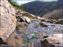
the scree cone just above the waterfall draining down from Niblock/Whyte.
I took a moment to stash a bottle of Sprite in a running stream for the
journey home. In retrospect, I should have left a non carbonated beverage
instead 'cause I found myself burping all the way back to the parking
lot. Maybe something like a tall can of Kokanee. Sprite
in the foreground and the big beehive in the background.
Once
we arrived at Lake Agnes, we made our way around the lake and towards
the scree cone just above the waterfall draining down from Niblock/Whyte.
I took a moment to stash a bottle of Sprite in a running stream for the
journey home. In retrospect, I should have left a non carbonated beverage
instead 'cause I found myself burping all the way back to the parking
lot. Maybe something like a tall can of Kokanee. Sprite
in the foreground and the big beehive in the background.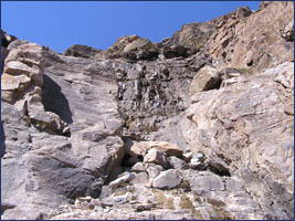 Like
all scree slopes, this one was a pain in the ass. The scree wasn't loose
like the crap found on Rundle but it was very steep. A faint trail near
the center of the cone offered some better traction but it was still a
little tiresome.
Like
all scree slopes, this one was a pain in the ass. The scree wasn't loose
like the crap found on Rundle but it was very steep. A faint trail near
the center of the cone offered some better traction but it was still a
little tiresome.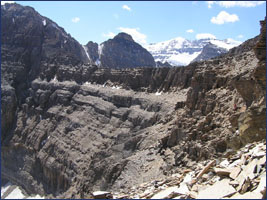 After
reaching the top of the scramble, it was basically a tiring slog to the
col between Niblock and Whyte. The angle was quite steep and the terrain
was mostly hard packed scree. Trails crisscrossed the entire route to
the top and there seemed to be cairns all over the place.
After
reaching the top of the scramble, it was basically a tiring slog to the
col between Niblock and Whyte. The angle was quite steep and the terrain
was mostly hard packed scree. Trails crisscrossed the entire route to
the top and there seemed to be cairns all over the place.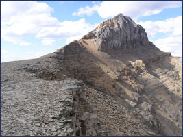

 After
a few minutes on the ridge, we encountered the gully (ascending to the
right) which is listed in the Scrambles book. The book does not recommend
climbing this gully and the reason is pretty obvious. Not only was this
gully steep and full of snow, any fall would result in you being ejected
from the mountain ! (If you look carefully at the image of Whyte above,
you can actually see the gully and it's extension below outlined in white.)
We slowly made our way up using the slabs to the right making sure we
had a good distance between us. We realized on the way down that the gully
was actually unnecessary since there was a trail above which bypassed
it altogether ! Look for a few steps about 2m before the gully on the
wall to your right. This is a much better alternative to the exposed gully.
After
a few minutes on the ridge, we encountered the gully (ascending to the
right) which is listed in the Scrambles book. The book does not recommend
climbing this gully and the reason is pretty obvious. Not only was this
gully steep and full of snow, any fall would result in you being ejected
from the mountain ! (If you look carefully at the image of Whyte above,
you can actually see the gully and it's extension below outlined in white.)
We slowly made our way up using the slabs to the right making sure we
had a good distance between us. We realized on the way down that the gully
was actually unnecessary since there was a trail above which bypassed
it altogether ! Look for a few steps about 2m before the gully on the
wall to your right. This is a much better alternative to the exposed gully.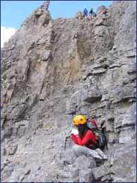 After reaching
the top of the gully, we walked up the notch above and crossed another
wide gully to find some people scrambling down from the ridge above. Although
it looked possible to continue traversing across this mountain to the
second gully, we decided to scramble up the first one since we were getting
tired of traversing across steep scree slopes.
After reaching
the top of the gully, we walked up the notch above and crossed another
wide gully to find some people scrambling down from the ridge above. Although
it looked possible to continue traversing across this mountain to the
second gully, we decided to scramble up the first one since we were getting
tired of traversing across steep scree slopes.